Fishing Closures for Southern BC Streams
Posted on July 20th 2015, by Rodney Hsu, webmaster
Due to the ongoing drought condition which Southern British Columbia has been experiencing, the BC Ministry of Forests, Lands and Natural Resource Operations has issued a closure for many streams in Region 2. From the news release:
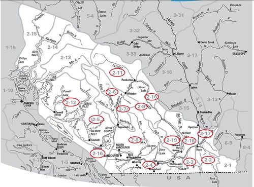
Effective July 22 through Sept. 30, 2015, virtually all angling in streams and rivers in Wildlife Management Units 2-2 through 2-12 and 2-16 through 2-19 is suspended. The geographic area ranges from south of Toba Inlet and the Toba River (which is not included in the closure) to the U.S. border. Lakes and reservoirs are not included in the closure. The closure has been put in place to protect fish stocks at a time when they are vulnerable due to low flows and high water temperatures.
The closure has a number of exceptions of larger streams with flows and temperatures currently suitable for a sustainable recreational fishery. These exceptions are for the following river mainstems: the Fraser (non-tidal portion), Chilliwack-Vedder, Harrison, Lillooet, non-tidal Squamish, non-tidal Pitt, Elaho, Cheakamus, Capilano (downstream of Highway 1 bridge) and Mamquam (downstream of CN railway bridge). However, the tributaries of these named exceptions are closed.
Wildlife Management Units 2-1 and 2-13 through 2-15 Wildlife Management Units 2-1 (Manning Park east of the Skagit River) and 2-13 through 2-15 (the areas around Toba Inlet and Bute Inlet) are also excluded from the closure. Streams in these areas are considered low risk due to low angling effort and/or glacial origins that keep them cooler.
You can see a map of the management units below and enlarge it by clicking on the map.